|
|
|||||||||||
 |
|||||||||||
 |
||||
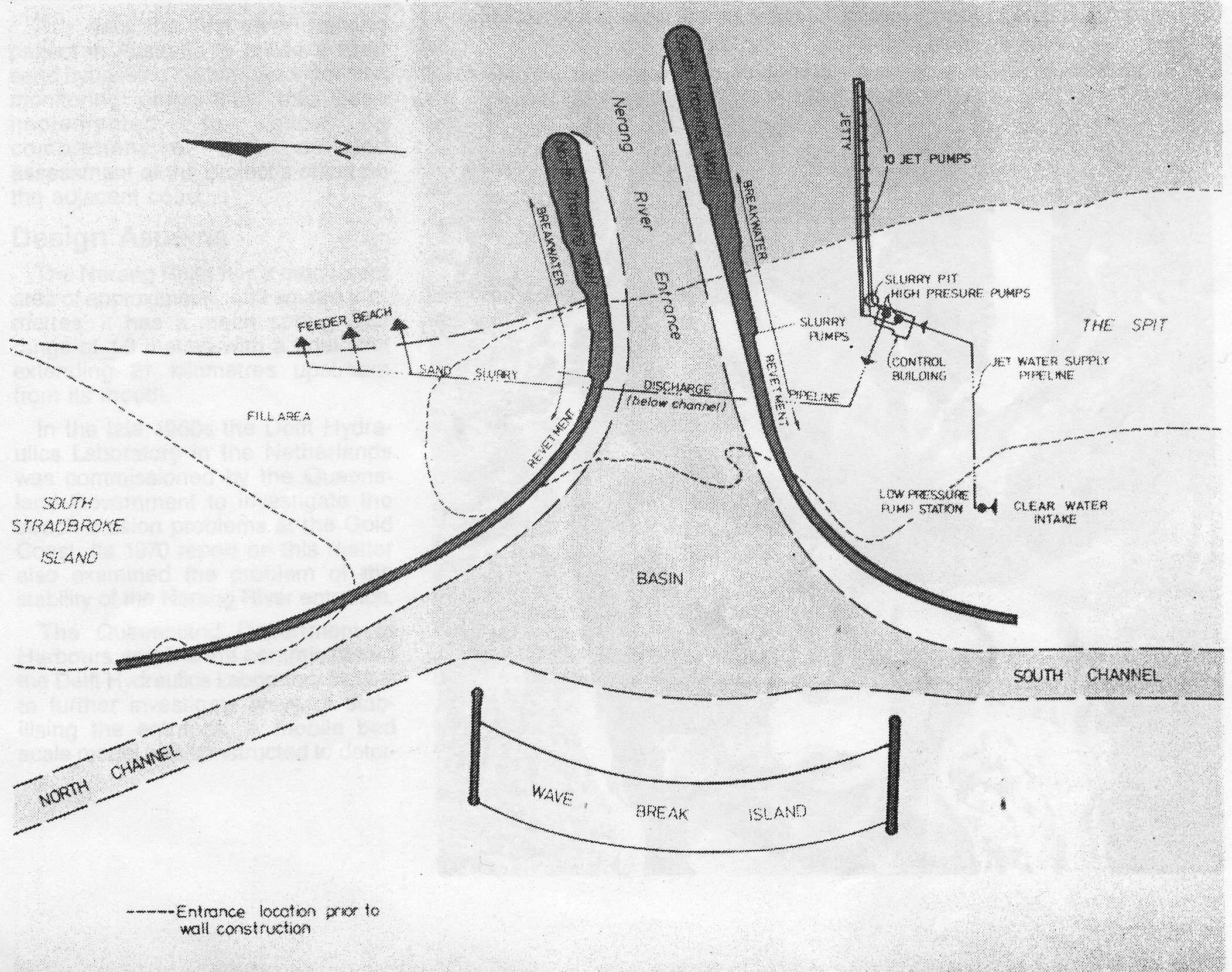
DESIGN DRAWING BEFORE CONSTRUCTION |
||||
 |
||||
|
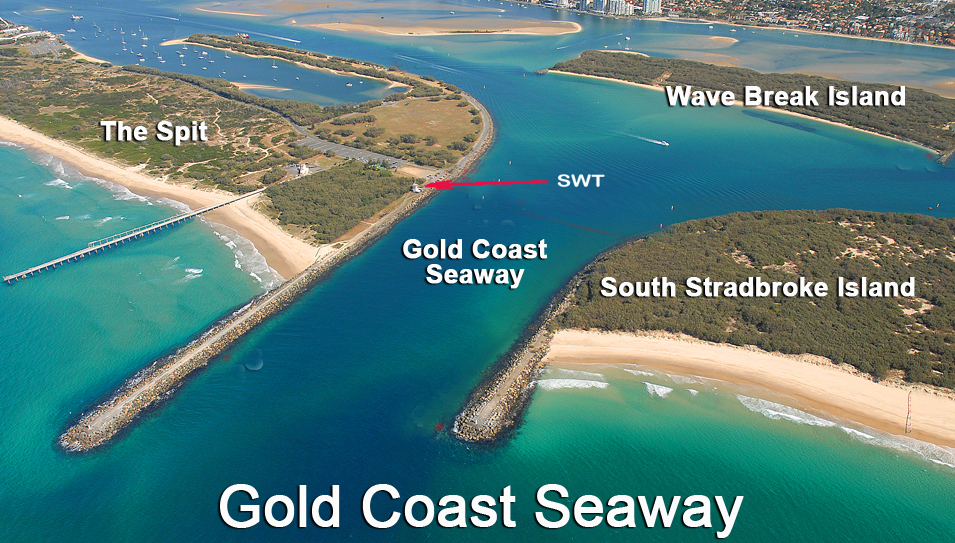
The story of The Gold Coast Seaway
By Paul Coughlan and David Robinson Department of Environment and Heritage Engineers with the Coastal Protection Unit of the Queensland This article is adapted from a paper presented in the Journal of the American Shore and Beach Preservation Association in 1990. Prior to training in 1984 the Nerang River entrance (or as it was more commonly called, the Southport Bar) had a notorious history of instability. Monitoring since 1840 had shown that the entrance was moving northwards, which from the early 1900s was at an average rate of between twenty and forty metres a year. This northward migration of the entrance was due to two combined effects:
The average northward net longshore transport rate is 500,000 cubic metres a year comprised of about 600,000 cubic metres to the north and 100,000 cubic metres to the south. There is a large variability in the amount of sand transported along the coast. During tropical cyclones, long-shore transport in the order of 100,000 cubic metres can occur in one week. The deep water wave heights at the site average from 0.8 metres to 1.2 metres. However, maximum deep water wave heights as large as 10 metres can be recorded during tropical cyclones. The northward migration of the entrance, which allowed the formation of a spit to the south, caused corresponding erosion at the southern end of South Stradbroke Island. As an example of this, the town of Moondarewa marked on the Cadastral Map in 1880 as being on South Stradbroke Island would have been in the middle of the mouth of the Nerang River in 1984. This migratory nature of the entrance resulted in continual changes to navigation channels, both in location and depth, which contributed to a significant number of boating accidents over the years. In its untrained state, the Nerang River entrance represented a major obstacle to the full development of the Broadwater and its adjacent tidal waters for recreational and commercial boating purposes. Training of the entrance was undertaken to overcome these problems. Sand Bypassing It was an important consideration of the project that training of the entrance would not have adverse consequences on the adjoining coastal system. Because the construction of the training walls would trap sand south of the river entrance with subsequent major down-drift erosion of South Stradbroke Island, the final design incorporated a permanent sand bypassing system. The sand bypassing system would also prevent the long term formation of shallow sand shoals seaward of the new entrance. This was the first river training project in Australia to utilize a fixed sand bypassing system. An extensive monitoring programme has been implemented to allow a comprehensive and detailed assessment of the project's effect on the adjacent coast. Design Aspects The Nerang River has a catchment area of approximately 480 square kilometers. It has a mean spring tidal range of 1.3 metres with a tidal limit extending 21 kilometers upstream from its mouth. In the late 1960s the Delft Hydraulics Laboratory in the Netherlands was commissioned by the Queensland Government to investigate the beach erosion problems at the Gold Coast. Its 1970 report on this matter also examined the problem of the stability of the Nerang River entrance. The Queensland Department of Harbours and Marine commissioned the Delft Hydraulics Laboratory in 1973 to further investigate ways of stabilizing the entrance. A mobile bed scale model was constructed to determine the project's design requirements. The Laboratory's report of 1976 presented some of the basic parameters which were used in the final design of the scheme. Among the many investigations undertaken for the Nerang River entrance project, fixed bed modeling of the training wall head design and wave penetration into the Broadwater was undertaken at the Queensland Government Hydraulics Laboratory. Investigation Results The conclusions reached from the many investigations of the Nerang River entrance project were:
After careful consideration of all factors relating to the proposal, the Queensland Government decided in 1983 that the entrance stabilization project should proceed. Project Description Two training walls were constructed about 300 metres apart just south of the original entrance. The southern training wall extends approximately 600 metres out to sea while the northern wall extends 400 metres seaward. A total of approximately 1 million tonnes of rock was transported to the site for use in the construction of the training walls. The crest of each training wall was constructed of two layers of 20 tonne concrete cubes placed to provide a stable working platform during construction. The training walls were armoured with rock of sizes up to 15 tonnes and were designed to withstand wave overtopping. At the exposed head of each training wall 25-tonne cubes were used as armour. A total of 4,500 concrete cubes were used in the works. Construction of the walls was carried out completely by land-based equipment. 4.5 million cubic metres of sand were dredged to form new access channels within the Broadwater and to provide a new entrance channel between the training walls. The sand from the dredging operations was used to close the old entrance and to construct the wave-break island. Closure of the old entrance was expected to be a critical operation due to high currents. However, closure was achieved without mishap by a 24 hours a day, seven days a week pumping operation over about a month. A sand bypassing system was constructed which consisted of 10 jet pumps at 11 metres below mean sea level positioned at 30 metre intervals along a trestle extending 490 metres into the sea. Water to power the jet pumps is drawn from the Broadwater via two low pressure pumps which feed another two high pressure pumps located in the control building. A sand-water mix from the jet pumps passes back along the bypass trestle through a gravity-fed flume into a slurry pit from where it is pumped to the southern end of South Stradbroke Island via a pipeline under the Seaway entrance. To achieve optimal efficiency, the system typically operates with a subset of 3 to 5 jet pumps running simultaneously, with the jet pumps being selected by computer. The system has been designed to handle the average northward longshore sand transport of 500,000 cubic metres a year although it has reserve capacity to handle higher rates during severe storm conditions. Unlike dredgers, the system can operate during violent storms, 24 hours a day if necessary. The pumps usually operate at night to take advantage of cheaper off-peak electricity. Almost 70 hectares of reclaimed areas of bare sand on wave-break island and at the southern end of South Stradbroke Island were re-vegetated with native plant species local to the coastal areas of the Gold Coast. A sewage effluent disposal system composed of 10 separate diffuser pipes located at 30 metre centres along the northern training wall was incorporated in the system. The principal dates associated with the Seaway project were: September 1984 - start of training wall construction November 1985 - breakthrough of new entrance December 1985 - closure of old entrance May 1986 - completion of construction and start of sand bypassing May 31, 1986 - Seaway officially opened. With the exception of the vegetative works, the project was effectively completed in May 1986 at a total cost of about $50 million. The major cost components were the contract performed by Leighton-Candac Joint Venture for the training walls construction and dredging at a total cost of about $31.5 million, and the design/construction contract for the sand bypassing trestle and pumping system by McConnell Dowell at a cost of about $6.3 million. Monitoring the Project In order to assess the performance of the project, and to quantify the effect on the adjacent coastline, an extensive monitoring programme was implemented. Regular surveys of the area surrounding the Seaway started in July 1984 and consisted of 50 shore-normal profile lines perpendicular to the shoreline covering the coastline for approximately two and three kilometres north and south of the new entrance respectively. Surveys were undertaken before and during the construction phase and have been repeated regularly since the opening of the Seaway. In addition, a second more detailed survey of an area approximately 500 metres north to 500 metres south and continuing through the entrance has been undertaken at regular intervals since the opening of the Seaway. This survey monitors changes and navigational clearances within the entrance as well as the movement of sand seaward of the training walls. This is useful in assessing the success of the sand bypassing system in suppressing the formation of any sand bar seaward of the entrance. The performance of the sand bypassing system is monitored on a daily basis. Records of the operating time for each jet pump, sand pumping quantity and energy consumption are maintained. Flow rate and sand concentration are measured continuously by an electromagnetic flow meter and a nuclear sensor in the discharge line. A wave recording buoy is located just to the south of the Seaway entrance in 15 metres of water. Another wave recording buoy is located 60 kilometres north of the Seaway in 60 metres of water offshore from Point Lookout on North Stradbroke Island. Wave data from both buoys is presently being used to more accurately asses the longshore sand transport rate at the Seaway. The aim is to align the sand pumping rate more closely to the actual time varying longshore rate. Water levels within the Broadwater were recorded at seven sites extending from the Broadwater to 20 kilometres upstream in the Nerang River to assess any changes in tidal levels within the Broadwater. Results indicate that low tides are now lower than in the mid 1980s. Effects on the Adjacent Coast The information collected by the monitoring programme has allowed an assessment of the project's performance and its effect on the adjacent coast. A twenty-month lag existed between the start of training wall construction and the start of sand bypassing across the entrance. Surveys indicate that close to 1 million cubic metres of sand had accumulated south of the Seaway over a 2 kilometre distance during this period. Because of the unexpected delay in the start of the construction of the sand bypassing system and the resultant large accumulation of sand south of the Seaway, the coastline south of the entrance was well seaward of its design location. For example, the average seaward movement of the -3.0 metre contour was approximately 130 metres over this twenty month period. The seaward movement of the southern coastline allowed some sand to leak past the end of the bypass jetty and form a shoal in the entrance channel just seaward of the southern training wall. In order to reduce this accumulated sand, an amount of sand in excess of the annual longshore transport rate was pumped across the entrance. The leakage of sand past the bypass trestle has not caused significant navigation problems to date as shoaling above the minimum design channel depth has been noted on only two occasions, coinciding with a period of very high waves. Nevertheless, there is a need to bring the coastline back to near its original position to minimize any further leakage of sand into the entrance. In the two years following the start of the sand bypassing system, surveys indicated that some 300,000 to 400,000 cubic metres of sand in excess of the longshore sand transport volume were bypassed, thus reducing the accumulated sand volume by 30 to 40 per cent. As a result of this excess pumping, the shoreline has moved back an average of 75 metres for a 2 kilometres distance south of the Seaway. Aerial photography indicates that sand can still leak past the seaward end of the bypass trestle despite the reduction in the accumulated sand volume, and further excess pumping is required to achieve a further pull back of that accumulation. There has been a reduction in the average monthly rate of sand pumping since early 1989. This was due to operational problems caused by debris being transported into the sand trap by large seas. Heavy rain in the catchment areas of the Gold Coast hinterland in late 1988 and early 1989 caused the creeks to the south of the Nerang River, as well as the Tweed River, to discharge large quantities of debris into the active coastal zone. The debris consists mainly of natural timbers and dune vegetation, with limited amounts of man made debris. The predominant northwards littoral drift ensured that this debris eventually reached the sand trap at the bypassing plant. A large trial jet pump has been used as a cleaning pump to remove debris from the sand trap. Before this, blockages in the jet pumps had to be manually removed, usually with the assistance of divers. The reduction in the recent sand bypassing quantities has not caused any entrance shoaling. It was always realized that dynamic coastline changes would occur north of the new entrance due to: closure of the old entrance, and the interruption in the longshore sand transport prior to the start of sand bypassing. For the 12 month period after the start of training wall construction the old entrance remained open. Following closure of the old entrance and the interruption in the sand supply from the south due to the groyne effect of the southern training wall, the ebb tide bar in the mouth of the old entrance gradually migrated shore-wards under the prevailing wave conditions. In addition, extensive pumping of sand into the area immediately north of the new entrance from dredging of new channels within Broadwater was undertaken. The training walls were built through the Spit to the south of the existing entrance.
Sand pumping from the dredging operations and the redistribution of sand from the old entrance compensated for the 1 million cubic metres of sand trapped to the south of the entrance prior to the start of the bypassing system. After the start of sand bypassing, aerial photography showed that by December 1986 a new beach had formed north of the entrance enclosing a lagoon between the new beach and the reclaimed area of the old entrance. Initially all bypassed sand was discharged directly into the lagoon reducing it in both area and depth. The lagoon is now north of the limit of the bypassing plant's capacity thus sand is being discharged directly into the active beach system to the north of the Seaway where normal longshore transport moves it away from the entrance. It is expected that the beach seaward of the lagoon will continue to reduce under prevailing wave conditions. An ebb tide bar has formed immediately to the north of the new entrance. This bar initially accumulated almost 800,000 cubic metres of sand and during this accumulation the outer limit of the bar moved about 275 metres seaward. However, this bar is at a depth of 8 metres which is well below the minimum navigation requirement of 5.5 metres. At the seaward boundary of the bar the seabed falls off steeply from 8 metres to 15 metres. The Seaway project design stipulated an entrance channel with a minimum design depth of 5.5 metres below mean sea level. Surveys since the Seaway's opening show that the entrance channel has adopted an asymmetrical cross-section, with scouring along the southern training wall to minus 13 metres; while shoaling has occurred along its northern bank to minus 3.5 metres. The scouring of the channel has not presented any structural problems as the toe of the training wall was designed to accommodate slumping. The scouring exposed part of the bypass pipeline which runs beneath the Seaway entrance leaving it suspended over a small distance. The pipeline was subsequently secured to the seabed. A uniform channel width of 170 metres was used for design purposes and despite the shoaling on the northern bank a channel width in excess of 170 metres is available below design depth. Summary he Gold Coast Seaway, built at a cost of approximately $50 million, is one of the most significant coastal engineering projects undertaken in Australia for many years. It is the first entrance stabilization scheme in Australia to incorporate a permanent sand bypassing system to minimize sedimentation of the navigation channel and to minimize any detrimental effects on the adjacent coast. From a technical viewpoint the project has significant achievements:
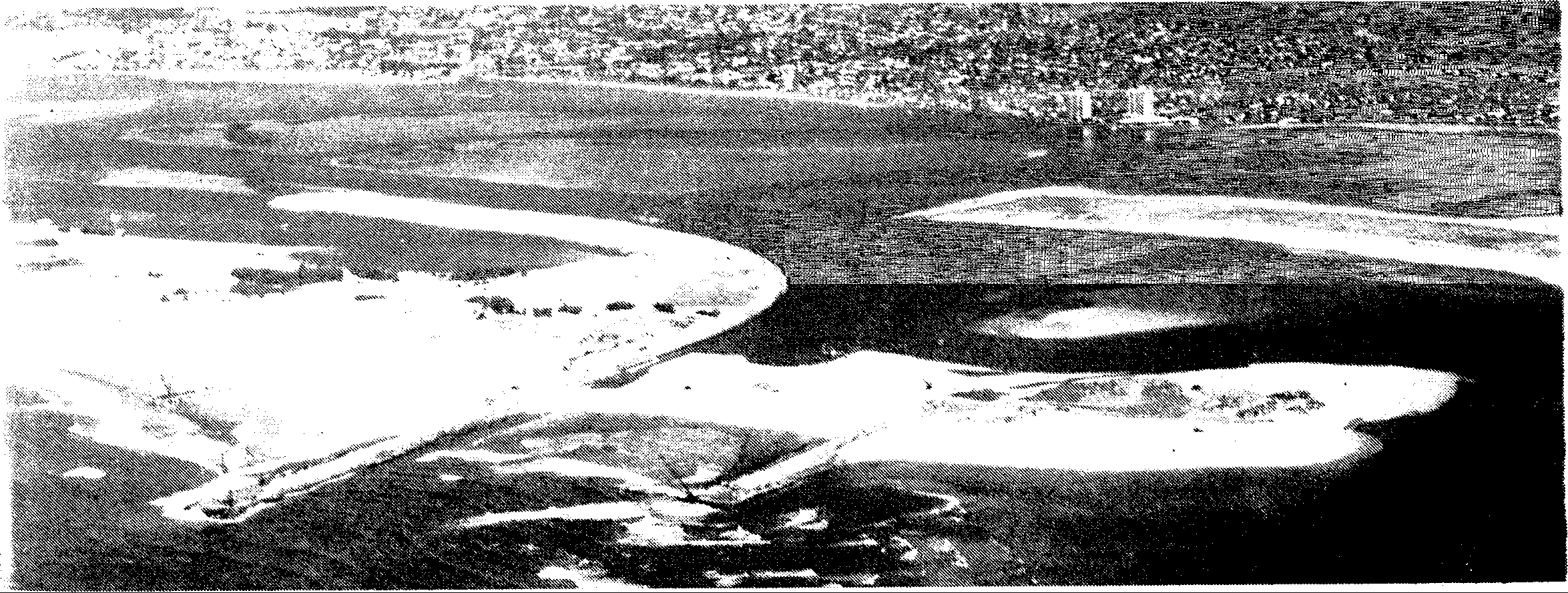
The main aim of the project was to provide a safe navigable entrance channel to the Broadwater, for both recreational and commercial vessels, without any associated adverse consequences on the adjacent coastline. Because of the successful and efficient operation of the sand bypassing system the project has achieved its goals and has helped to establish the Broadwater as one of Australia's best boating areas. Aerial photograph taken in November 1985 before the original entrance
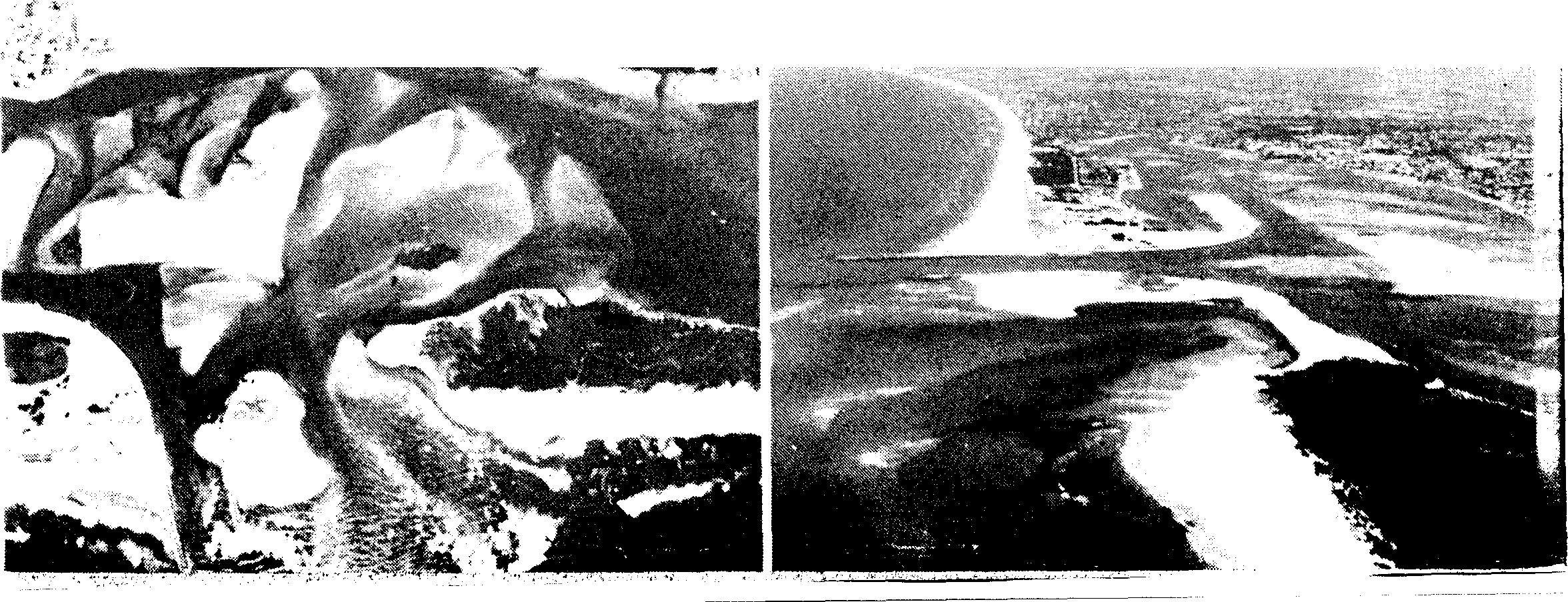
The trained river entrance shortly after completion.
|
 |
| [Home] [News] [Services] [About Us] [FAQ] [Location] [History] [Contact Us] |